 OHDSI GIS
 OHDSI GIS
WG
Architecture & Data Flows
This page describes the technical architecture of the Gaia toolchain, including component interactions, data flows, and design principles.
System Architecture Overview
The Gaia toolchain consists of multiple interconnected components that work together to integrate geospatial data with the OMOP Common Data Model.
High-Level Architecture
┌─────────────────────────────────────────────────────────────────┐
│                    External Data Sources                         │
│  (Census, EPA, Weather, Social Services, Geographic Boundaries)  │
└────────────────────────────┬────────────────────────────────────┘
                             │
                             ▼
┌─────────────────────────────────────────────────────────────────┐
│                       gaiaCatalog                                │
│  • Data source discovery                                         │
│  • Metadata (JSON-LD) and ETL scripts per dataset                │
│  • Schema.org compliance                                         │
└────────────────────────────┬────────────────────────────────────┘
                             │
                             ▼
┌─────────────────────────────────────────────────────────────────┐
│                        gaiaDB                                    │
│  • PostgreSQL/PostGIS database                                   │
│  • Catalog-driven ingestion (ETL scripts)                        │
│  • Geometry-attribute index                                      │
│  • Per-source geometry and attribute tables                      │
└────────────────────────────┬────────────────────────────────────┘
                             │
                             ▼
┌─────────────────────────────────────────────────────────────────┐
│                       gaiaCore                                   │
│  • R package (direct database connection)                        │
│  • Pipeline: ingestion, locations, spatial-temporal join         │
│  • Quality checks, copy into the OMOP CDM                        │
│  • Exposure analytics                                            │
└────────────────────────────┬────────────────────────────────────┘
                             │
                             ▼
┌─────────────────────────────────────────────────────────────────┐
│                  OMOP CDM + GIS Extensions                       │
│  • Location_History table                                        │
│  • External_Exposure table                                       │
│  • Integrated with standard OMOP tables                          │
└────────────────────────────┬────────────────────────────────────┘
                             │
                             ▼
┌─────────────────────────────────────────────────────────────────┐
│                     HADES Analytics                              │
│  • Cohort definition                                             │
│  • Patient-level prediction                                      │
│  • Population-level estimation                                   │
│  • Evidence generation                                           │
└─────────────────────────────────────────────────────────────────┘
Component Details
1. gaiaCatalog
Purpose: Data source discovery and metadata management
Technology: Schema.org JSON-LD (Science on Schema.org profile), KoboToolbox authoring with SSSOM mapping, SHACL validation, optional Solr search index
I/O: External data URLs/metadata → Catalog entry (JSON-LD metadata plus the ETL scripts that retrieve and load the dataset)
2. gaiaDB
Purpose: Core data repository with all geospatial processing logic and OMOP integration
Technology: PostgreSQL/PostGIS (the reference image uses PostgreSQL 16 with PostGIS 3.5); PostgREST optional
Processing: SQL routines, PostGIS functions,
spatial-temporal joins and temporal alignment. Every source is
registered in the geometry-attribute index (geom_index,
attr_index) so the same join serves all of them. The index
covers vector geometries today.
I/O: Catalog entries + person locations and
residence histories → working.external_exposure (copied
into the CDM’s EXTERNAL_EXPOSURE by gaiaCore)
Schemas: backbone (metadata, indexes,
ingestion and catalog functions), working (locations,
per-source geometry and attribute tables, exposures),
vocabulary (OMOP vocabulary tables), public
(raw source tables loaded by each dataset’s ETL scripts)
3. gaiaCore
Purpose: R interface to gaiaDB: runs the pipeline, checks the derived exposure and provides exposure analytics (no spatial processing logic of its own)
Technology: R package using DatabaseConnector
(JDBC); Docker image ohdsi/gaia-core (HADES + gaiaCore)
I/O: Catalog dataset ids, person locations → gaiaDB
functions → exposure rows → OMOP EXTERNAL_EXPOSURE,
summaries and estimates in R
Key: gaiaCore calls gaiaDB’s SQL functions. All
spatial processing happens in gaiaDB. The Python, Java, Julia and Bash
clients and the PostgREST-based R client live on the gaiaCore
connectors branch.
Data Flow Details
End-to-End Data Flow
Phase 1: Data Discovery
External Source → gaiaCatalog
    Input: Dataset URL, documentation
    Process: Metadata extraction, cataloging
    Output: Cataloged data source with metadata
Phase 2: Data Ingestion
Cataloged Source → gaiaDB
    Input: Raw geospatial files (retrieved by the entry's ETL scripts)
    Process: Metadata load, download and load into PostGIS, geometry clean-up, registration in the index
    Output: Per-source geometry and attribute tables (vector sources)
Phase 3: Exposure Calculation
Patient Locations → gaiaDB (loaded and joined from R with gaiaCore)
    Input:
        - Patient geocoded addresses
        - Residence time periods
        - Variable specifications
        - Location_History records
    Process (in gaiaDB):
        - Spatial joins (PostGIS)
        - Temporal alignment (SQL)
        - Each value clipped to the residence interval
        - No addresses leave the site
    Output:
        - External_Exposure records
Phase 4: OMOP Integration
gaiaDB Output → OMOP CDM
    Input: Processed exposure data
    Process:
        - Map to OMOP vocabulary concepts
        - Link to Location table (privacy-preserved)
        - Link to Person via Location_History
        - Populate External_Exposure table
    Output: OMOP CDM with integrated geospatial exposures
Phase 5: Analytics
OMOP CDM + GIS Extensions → HADES
    Input: Integrated clinical + geospatial data
    Process: Standard OHDSI analytics
    Output: Evidence generation
Privacy Architecture
Gaia enables geospatial analysis without sharing sensitive patient addresses. It runs beside the CDM, inside the data holder’s site:
- Geocoding at site - Addresses are geocoded locally (or the site starts from ZIP codes or tracts it already holds)
- Locations and dates in, exposures back - Gaia joins public place data to where and when patients lived, inside the site; new rows land in EXTERNAL_EXPOSURE
- Nothing identifying leaves - Addresses, coordinates and location histories stay in the site’s enclave. In a network study, code goes out and only aggregate results come back, and only if the site chooses
- Locations stay protected - A home location is identifying even without a name, so the location tables stay inside the protected environment
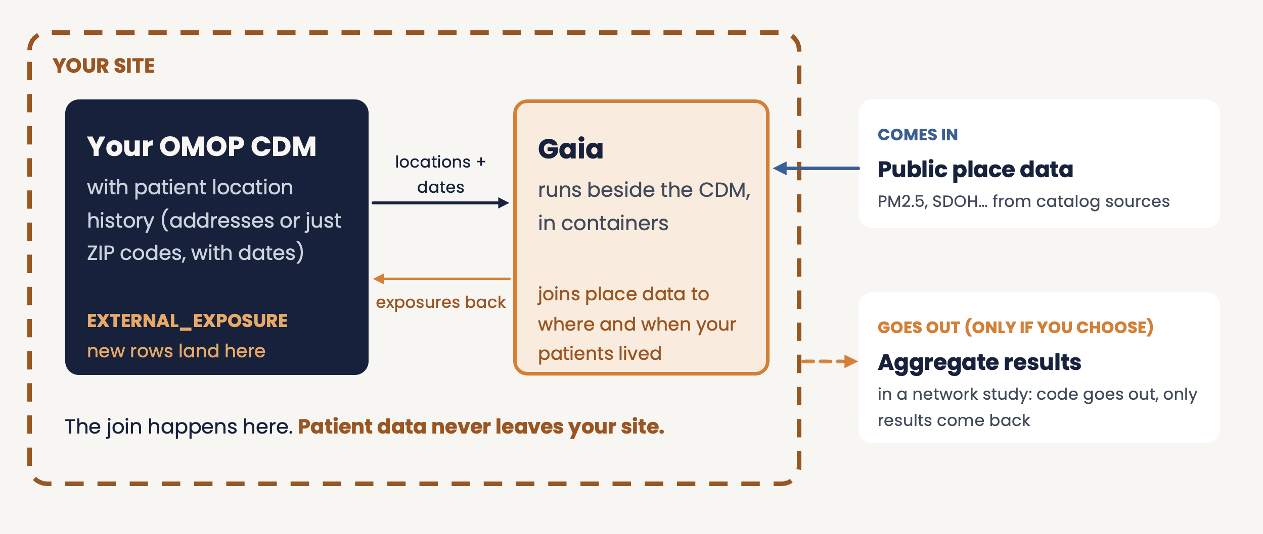
Workflow: Raw address (protected) → Geocode locally → Locations and dates to Gaia → Exposures back to the CDM → Aggregate results (optional)
Containerization helps keep geospatial processing separate from protected clinical systems, but it is not sufficient on its own: institutional governance, data-flow controls and local review remain required.
Design Principles
- Separation of Concerns: gaiaCatalog (discovery), gaiaDB (processing), gaiaCore (access), gaiaDocker (deployment)
- Standards: OMOP CDM, Schema.org, OGC geospatial, OHDSI vocabulary
- Privacy: No PHI sharing, local geocoding, patient locations stay in the site’s enclave
- Modularity: Independent components, clear interfaces, pluggable sources
- Reproducibility: Version-controlled catalog entries, documented provenance, open source
Inputs and Outputs by Component
gaiaCatalog
| Input | Format | Output | Format |
|---|---|---|---|
| Dataset URL | String | Catalog entry | JSON-LD |
| Metadata | Schema.org | Searchable index | Database |
| Variables | CSV/JSON | Variable catalog | JSON |
gaiaDB
| Input | Format | Output | Format |
|---|---|---|---|
| Shapefiles | .shp | PostGIS tables | SQL |
| GeoJSON | .geojson | Indexed geometries | PostGIS |
| Raster | .tif, .nc | Staging tables (registration in the index is planned) | PostGIS |
| CSV with coords | .csv | Point geometries | PostGIS |
| Catalog entry (ETL scripts) | JSON-LD, shell | Registered per-source tables | PostGIS |
| Patient locations and residence periods | Geocoded coords | External_Exposure | OMOP table |
| Variable IDs | Integer | Exposure values | Numeric |
| SQL function calls | SQL | Query results | Tabular |
gaiaCore
| Input | Format | Output | Format |
|---|---|---|---|
| Catalog dataset ids | Character | Ingested datasets, variable tables | gaiaDB tables |
| Locations and residence histories | Data frames / OMOP tables | Loaded working tables |
gaiaDB tables |
| Variable name, spatial operator | Function call | Exposure rows | EXTERNAL_EXPOSURE |
| Exposure rows, windows, outcomes | Data frames | Quality checks, windowed exposure, effect estimates | Data frames |
| Connection params | connectionDetails |
Database access | JDBC connection |
gaiaDocker
| Input | Format | Output | Format |
|---|---|---|---|
| docker-compose.yaml | YAML | Running containers | Docker services |
| Profile selection | CLI flag | Stack configuration | Deployed services |
| Environment config | .env | Service parameters | Runtime config |
| Component images | Docker | Orchestrated stack | Running Gaia toolchain |
OMOP Integration
Extension Tables: Location_History (patient-location-time), External_Exposure (place-based exposures)
HADES: Standard packages work with extended CDM, cohort definitions can include exposure criteria
See Schema Extensions for complete DDL.
Performance & Scalability
- Indexing: GIST spatial indexes, materialized views
- Caching: Datasets, transformations, API responses
- Scaling: Connection pooling, batch processing; heavy work stays in gaiaDB
- Join cost: The catalog-driven join is somewhat slower than an equivalent hand-written PostGIS query and returns identical rows; its value is provenance, standardization and reuse, not speed.
See Deployment Strategies for deployment options.
Future Enhancements
Planned: Raster support in the index, geometry hierarchies and boundary validity periods, a declarative recipe layer (under evaluation), real-time data streams, ML integration, multi-site federation, enhanced catalog, unified API gateway
Research: Differential privacy, federated learning, spatiotemporal modeling